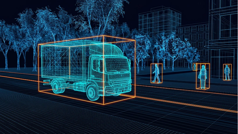
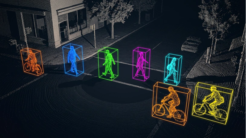
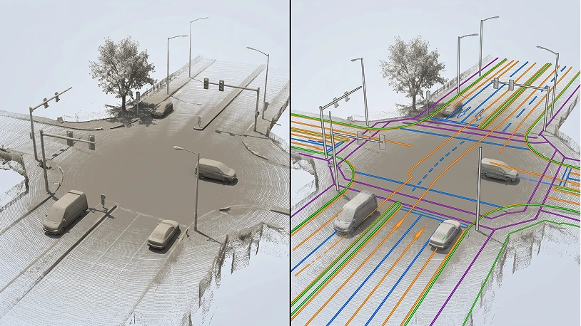
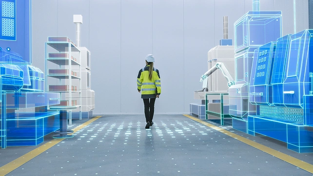
Lidar Annotation and Labeling Services

Image

Unidata provides a comprehensive suite of services for precise LIDAR point cloud annotation, guaranteeing the creation of high-quality training datasets tailored for sophisticated machine learning applications. Our meticulous approach ensures that your datasets meet the specific requirements needed to enhance model performance and accuracy.

Get in touch View cases
95%+ annotation accuracy
1,000+ domain-matched annotators
Pilot launched within days

Data Annotation Vs Labeling Tasks

LiDAR Data AnnotationLiDAR Data Labeling
DefinitionPrecise marking of objects, surfaces, and movement within LiDAR point cloud sequences, including per-point classification, 3D bounding volumes, object tracking across frames, and free space mappingAssigning classification labels to LiDAR-detected objects or scenes without per-point precision, typically at cluster or frame level for basic environment understanding
Work CoverageComprehensive spatial-temporal coverage: processes every point in every sweep, tracks objects continuously through occlusions, maps empty space, identifies motion vectors, and maintains temporal consistency across entire sequencesSelective object-level coverage: processes only detectable object clusters, labels primary actors in scenes, treats sweeps independently, and captures presence/absence without detailed spatial boundaries
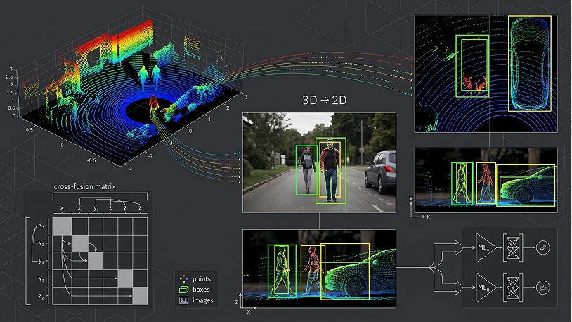
Common Tasks• 3D bounding cuboid annotation with orientation
• Point-wise semantic segmentation (every point classified)
• Multi-object tracking across sequential sweeps
• Free space vs. occupied space mapping
• Ground plane segmentation
• Motion vector and velocity annotation
• Occlusion boundary identification
• Sensor fusion alignment point marking
• Road boundary and lane marking detection
• Infrastructure element annotation (signs, poles)
• Dynamic vs. static object classification per point
• Object type classification per cluster (vehicle/pedestrian/cyclist)
• Scene-level classification (highway/intersection/rural)
• Simple object presence/absence per sweep
• Obstacle vs. non-obstacle flagging
• Weather/condition tagging (rain/fog/clear)
• Time-of-day categorization
• Zone-based occupancy counting
• Basic traffic density estimation
• Coarse object counting per frame
Complexity LevelExtremely high complexity: requires deep understanding of LiDAR sensor characteristics (beam pattern, intensity, reflectivity), point cloud geometry, occlusion patterns, temporal dynamics, and real-world object behavior across varying conditionsMedium complexity: requires ability to interpret point cloud visualizations, recognize object types, and apply consistent classification rules without fine-grained spatial analysis
ML ImpactEnables: Level 4/5 autonomous driving perception, real-time obstacle tracking and prediction, HD map creation and validation, sensor fusion model training, simulation environment generation, safety-critical decision systemsEnables: traffic monitoring analytics, basic ADAS features, environment trend analysis, fleet behavior studies, coarse validation of perception systems
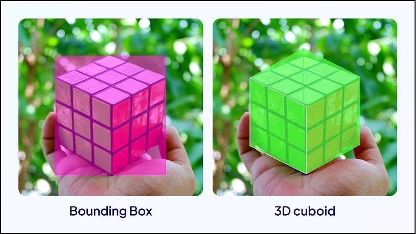
Lidar Annotation Data Annotation Types

Image

3D Bounding Box Annotation

Draws 3D boxes around objects in LiDAR point clouds to define their spatial dimensions. Used for detecting vehicles, pedestrians, and buildings in autonomous driving, robotics, and complex 3D scenes.
Image

Semantic Segmentation

Classifies each individual point in a LiDAR point cloud into specific categories like road surfaces, vehicles, or trees. Used for scene understanding, 3D mapping, and smart city planning with ML models.
Image

Instance Segmentation

Identifies individual instances of objects within LiDAR point clouds, labeling each separately. Essential for autonomous vehicle navigation and robotics requiring precise tracking across three-dimensional spaces.
Image

Polygon annotation

Draws lines representing road lanes, boundaries, and paths within LiDAR point clouds. Critical for mapping road networks, lane marking detection, and infrastructure planning using detailed 3D data.
Image

Point Annotation

Marks specific key points of interest within a LiDAR point cloud to pinpoint landmarks and critical object locations. Used in environmental monitoring, construction, and precise 3D perception tasks.
Image

Cuboid Annotation

Labels objects with 3D cuboids capturing depth, width, and height within LiDAR point clouds. Used to annotate vehicles, pedestrians, and objects in complex 3D spaces for object detection models.
Image

2D Projection from 3D Point Clouds

Projects raw LiDAR point cloud data onto 2D images for combined labeling. Merges spatial accuracy of LiDAR technology with 2D annotation simplicity, enhancing computer vision and ML model training.
Image

Terrain and Elevation Annotation

Labels elevation and terrain features including hills, valleys, and cliffs within LiDAR point clouds. Used in topographical mapping, drone imagery analysis, surveying, and detailed 3D maps for environmental monitoring.
Image

3D Object Tracking

Labels objects across multiple frames to track their movement through three-dimensional spaces. Essential for autonomous driving and robotics where continuous tracking of detected objects supports decision-making.
Image

Environmental Object Annotation

Labels static elements like buildings, trees, and roads within LiDAR point clouds. Applied in city planning, infrastructure development, and environmental monitoring requiring detailed 3D mapping and annotation techniques.

The best software for Lidar annotation tasks

Scale AI

Image

Scale AI is a highly versatile platform known for its ability to handle complex annotation tasks, including LiDAR point clouds. It offers a variety of automation tools and is widely used in industries like autonomous driving and robotics.

Best For:

Enterprises and teams working on large-scale LiDAR projects requiring high-quality annotations for autonomous systems.

Key Features

  • Advanced tools for 3D point cloud annotation, including segmentation and 3D bounding boxes.
  • AI-powered automation to accelerate the annotation process.
  • Real-time quality assurance to ensure accuracy.
  • Scalable for large datasets with efficient task management.

Labelbox

Image

Labelbox is a comprehensive annotation platform designed to simplify the labeling process for LiDAR data. It integrates machine learning tools to assist with labeling and offers easy collaboration for team-based projects.

Best For:

Teams that need a highly customizable annotation platform for managing LiDAR data and require collaboration features for large, multi-disciplinary teams.

Key Features

  • Support for 3D point cloud annotation with flexible tooling.
  • AI-driven suggestions to speed up manual annotation.
  • AI-driven suggestions to speed up manual annotation.
  • Rich data governance and security features.

CVAT (Computer Vision Annotation Tool)

Image

CVAT is an open-source annotation tool known for its flexibility and ease of use in handling LiDAR data. It’s designed for computer vision tasks and is favored by researchers and companies that need a reliable tool for 3D data labeling.

Best For:

Companies or research teams that want an open-source, flexible tool for custom LiDAR annotation needs.

Key Features

  • Support for 3D point clouds, as well as 2D and video annotations.
  • Open-source with full control over customization.
  • Integrated automation tools to reduce manual effort.
  • Suitable for small and large datasets alike.

CloudAnnotation

Image

CloudAnnotation is a cloud-based annotation tool with support for both 2D and 3D data, including LiDAR point clouds. It provides a simple interface, making it easy to manage and annotate complex data sets efficiently.

Best For:

Small to medium-sized teams that need an accessible and user-friendly LiDAR annotation tool in the cloud.

Key Features

  • Support for 3D LiDAR annotation, including point cloud segmentation and object detection.
  • Web-based interface for easy accessibility and collaboration.
  • Automated tools to assist with repetitive annotation tasks.
  • Built-in version control and data management.

3D Point Studio by Voxel51

Image

Voxel51's 3D Point Studio is a specialized platform for annotating LiDAR data, focusing on providing powerful visualization and segmentation tools for handling 3D point clouds in various applications like autonomous driving and robotics.

Best For:

Teams working on autonomous driving or robotics who need advanced 3D visualization and annotation tools.

Key Features

  • Intuitive 3D visualization tools for precise point cloud annotation.
  • Rich support for object segmentation, labeling, and tracking.
  • AI-assisted workflows to enhance annotation accuracy and speed.
  • Collaboration tools to manage teams and large-scale datasets.

VoTT (Visual Object Tagging Tool)

Image

VoTT is an open-source annotation tool developed by Microsoft that supports various data formats, including 3D point clouds. It is ideal for teams looking for a free, customizable option for annotating LiDAR data.

Best For:

Small teams or individual users looking for a free, open-source solution with solid support for LiDAR annotations.

Key Features

  • Support for 3D and 2D annotations, including point cloud data.
  • Extensible and customizable for different types of annotation workflows.
  • Integrates with popular machine learning frameworks for seamless model training.
  • Lightweight tool suitable for both small and large-scale projects.

Scaleit

Image

Scaleit is a LiDAR annotation platform designed specifically for large-scale projects, offering advanced tools for handling complex 3D data. It includes high levels of automation, making it ideal for enterprises dealing with extensive point cloud data.

Best For:

Large-scale projects with high volumes of LiDAR data, particularly for enterprises in the autonomous vehicle industry.

Key Features

  • Full support for 3D point clouds, including bounding boxes, segmentation, and more.
  • Automation tools that significantly reduce manual annotation time.
  • Collaboration and project management tools to handle large teams and datasets.
  • Seamless integration with cloud storage and machine learning pipelines.

How Unidata Provide Data Labelling Process

A Clear, Controlled Workflow From Brief to Delivery

01 Kickoff Briefing and Task Setup
You
Share your raw data, annotation requirements, and quality standards
Unidata
We analyze your data, define the methodology, and assign a dedicated project lead. The right annotation type and domain-matched annotators are confirmed before anything starts.
02 Pilot & Scoping Pilot and Estimate
You
Review annotated samples, validate quality, and approve scope before full-scale work begins.
Unidata
We annotate a small representative sample and deliver a clear cost estimate broken down by complexity, hours, and validation rounds.
03 Legal & Confidential Agreement and NDA
You
Review and sign. Scope, quality thresholds, and deadlines are all defined in writing upfront.
Unidata
We prepare a full confidentiality agreement covering your data, guidelines, and any proprietary model details.
04 Technical Setup Tools and Workflow Configuration
You
Share existing guidelines and format requirements. No guidelines yet? We build them together.
Unidata
We configure the right annotation platform for your data type: Labelbox, SuperAnnotate, CVAT, or Label Studio. Workflows, label taxonomy, and quality benchmarks are set before a single label is applied.
05 Execution Annotation in Progress
You
Review sample batches at each milestone and share feedback with your project lead.
Unidata
Trained, domain-matched annotators work through your dataset. No batch moves forward without passing internal quality checks.
06 QA Human-in-the-Loop Review
You
Review edge cases and confirm acceptance criteria before final delivery.
Unidata
Every batch goes through automated validation and human review. Inter-annotator agreement (IAA) is tracked throughout. Inconsistencies are caught and resolved before the dataset moves forward.
07 Delivery Production-Ready Dataset
You
Receive your annotated dataset in the format you need: COCO, Pascal VOC, JSON, CoNLL, PCD, or custom. Full quality report included.
Unidata
Clean, validated, training-ready data delivered on schedule. Final invoice aligned to the scope agreed at Step 02.

Have questions about the process? Every project starts with a free consultation — no commitment required.

Request Custom Research

Data Annotation Challenges? Value You Get with Unidata

Real Challenges

  • No annotators, tools, or workflow to process collected data
  • No quality check on labeled data before it hits the pipeline
  • No way to ensure two annotators label the same object consistently
  • Can’t find annotators with LiDAR, medical, or financial expertise
  • Scope creep and rework cycles exhaust the budget before delivery

Value with Unidata

  • Project lead assigned and pilot launched within days
  • Every batch validated before delivery, 95%+ accuracy via multi-stage QA
  • Label consistency tracked per batch, issues caught before training fails
  • 1,000+ annotators matched by domain — the right expert, every time
  • Pilot-first pricing, fixed scope, zero hidden rework charges

Data Annotation Files Example

Working with annotation data from CVAT and JSON formats, you'll receive optimized code that seamlessly processes both file types, complete with practical examples and visual representations of your data structure.

What our clients are saying

UniData

4 3 Reviews

PA

Paul 2025-02-21

Very Positive Experience!

The team was very responsive when requesting a specific dataset, and was able to work with us on what data we specifically needed and custom pricing for our use case. Overall a great experience, and would recommend them to others!

TH

Thorsten 2025-01-09

Very good experience

We got in touch with UniData to buy several datasets from them. Communication was very cooperative, quick, and friendly. We were able to find contract conditions that suited both parties well. I also appreciate the team's dedication to understand and address the needs of the customer. And the datasets we bought from UniData matched with our expectations.

Max Crous 2024-10-08

Data purchase

Our team got in touch with UniData for purchasing video data. The team at UniData was transparent, timely, and pleasant to communicate and negotiate with. Their samples and descriptions aligned well with the data we received. We will certainly reach out to UniData again if we're in search of 3rd party video data.

Abhijeet Zilpelwar 2025-02-26

Data is well organized and easy to…

Data is well organized and easy to consume. We could download and use it for training within few hours of receiving the data links.

Trusted by the world's biggest brands

FAQ

What are lidar data annotation services?
Lidar data annotation services involve labeling raw LiDAR data such as point clouds, laser scans, and 3D maps to create structured training datasets for AI and ML models. This process includes accurately annotating millions of 3D points with class labels and spatial attributes so systems can understand objects, depth, and relationships in three-dimensional spaces.
Why are lidar data annotation services important for AI and ML?
These services provide essential training data for ML models that rely on LiDAR technology and spatial understanding. Properly annotated datasets improve object detection, scene analysis, and 3D perception, enabling AI systems to make accurate decisions in real-world environments.
What types of lidar annotation do you support?
We support multiple annotation techniques, including 3D cuboids, semantic segmentation, polyline annotation, and object classification. These methods enable precise object identification, accurate boundary delineation, and detailed analysis of complex 3D scenes using LiDAR point clouds and spatial coordinates.
What are the risks of poor-quality lidar annotation?
Low-quality LiDAR annotation can lead to inaccurately trained datasets and reduced performance of ML models. Mistakes in labeling 3D points or spatial relationships can negatively affect detection algorithms, increase retraining costs, and reduce reliability in autonomous systems and robotics applications.
What level of annotation accuracy can we expect?
Our lidar data annotation services deliver 95%+ accuracy, validated daily by the Quality Control Department (QCD). Accuracy targets are defined based on dataset complexity, point density, and project requirements before annotation begins.
Can I order a pilot project?
Yes, Unidata offers pilot projects so teams can evaluate annotation quality, workflows, and compatibility with their ML models. This helps validate results before scaling to large and complex LiDAR datasets.
How is our data kept secure?
All our lidar data annotation services are GDPR and CCPA compliant, and we operate on AWS infrastructure certified under ISO 27001 and ISO 27701. Strict access controls ensure secure handling of raw LiDAR data throughout the annotation process.
How do you ensure the quality of lidar annotations? Do you use automation for validation?
We combine experienced annotators with structured validation workflows to ensure consistent and precise annotation of complex 3D LiDAR data. Each project goes through multiple review stages to maintain accuracy in labeling objects and spatial relationships. We track key metrics such as Error Rate, IAA (Inter-Annotator Agreement), and IoU (Intersection over Union), and use benchmark (“golden”) samples to evaluate performance. AI-assisted annotation tools and labeling platforms improve efficiency while maintaining high precision.
How long does it take to complete a lidar annotation project?
Delivery timelines depend on dataset size, LiDAR density, and annotation complexity, with each project evaluated individually for accuracy.
What technical support do you provide after purchasing lidar data annotation services?
Clients receive continuous support from our project managers throughout the annotation process, ensuring smooth communication, quick issue resolution, and alignment with your ML and AI objectives.

Industries

Image

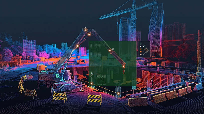
Construction & Architecture

Building models for site planning, structural monitoring, and code compliance verification.

Image

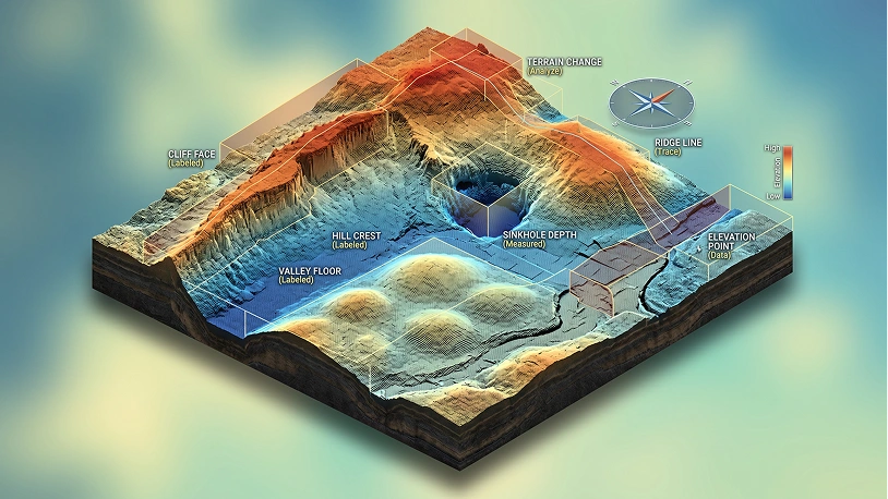
Environmental Monitoring

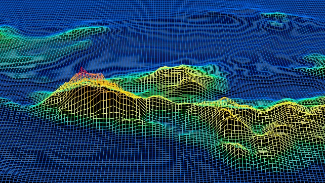
Landscape analysis for tracking deforestation, erosion, and climate change impact assessment.

Image

Agriculture

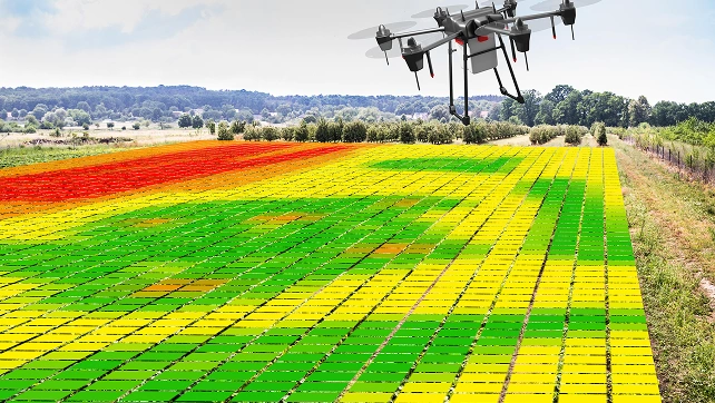
Field mapping for crop health monitoring, pest detection, and precision resource management.

Image

Healthcare

Medical 3D imaging for tumor detection, surgical planning, and accurate anatomical visualization.

Image

Real Estate

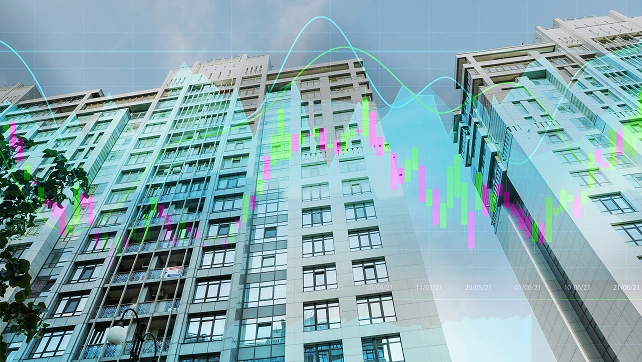
Property 3D modeling for enhanced listings, virtual tours, and accurate spatial visualization.

Image

Automotive

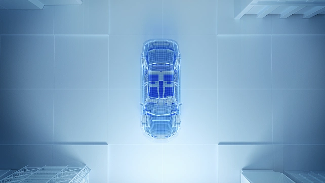
3D environment perception for safe navigation, obstacle detection, and real-time decisions.

Image

Security & Surveillance

Monitoring for movement tracking, threat detection, and real-time situational awareness.

Image

Manufacturing

Quality control, defect detection, and warehouse optimization through 3D scanning.

Why Companies Trust Unidata’s Services for ML/AI

Share your project requirements, we handle the rest. Every service is tailored, executed, and compliance-ready, so you can focus on strategy and growth, not operations.

Rely on 1,100+ Experts

  • 1,100+ in-house labelers and specialists
  • Consistent quality and rapid scaling
  • Complex multi-type annotation projects
01

Discover 19+ Industry Expertise

  • Finance, IT, E-commerce, Retail, Healthcare, Medical, Fintech, and more
  • Deep domain knowledge for industry-specific requirements
  • Support for industry-specific annotation challenges
02

Get Turnkey Services for ML/AI

  • From data collection to labeling and validation
  • Project tailored to your requirements
  • Complex annotation, multiple annotation types at once
03

Ensure Legal & Secure Data

  • GDPR & CCPA compliant
  • AWS ISO 27001/27701 storage
  • Curated and legally sourced
04

Process Different Content Types

  • Multimodal Data: 333K+ texts, 550K+ audio, 11K+ videos, 26K+ images
  • Formats: DICOM, LiDAR, and specialized types
  • Annotation: multiple types at once with high accuracy
05

Request Custom Research

Have questions about the process? Every project starts with a free consultation — no commitment required.

Explore our cases

Ready to get started?

Tell us what you need — we’ll reply within 24h with a free estimate

    What service are you looking for? *
    What service are you looking for?
    Data Labeling
    Data Collection
    Ready-made Datasets
    Human Moderation
    Medicine
    Other
    What's your budget range? *
    What's your budget range?
    < $1,000
    $1,000 – $5,000
    $5,000 – $10,000
    $10,000 – $50,000
    $50,000+
    Not sure yet
    • United States+1
    • United Kingdom+44
    • Afghanistan (‫افغانستان‬‎)+93
    • Albania (Shqipëri)+355
    • Algeria (‫الجزائر‬‎)+213
    • American Samoa+1684
    • Andorra+376
    • Angola+244
    • Anguilla+1264
    • Antigua and Barbuda+1268
    • Argentina+54
    • Armenia (Հայաստան)+374
    • Aruba+297
    • Australia+61
    • Austria (Österreich)+43
    • Azerbaijan (Azərbaycan)+994
    • Bahamas+1242
    • Bahrain (‫البحرين‬‎)+973
    • Bangladesh (বাংলাদেশ)+880
    • Barbados+1246
    • Belarus (Беларусь)+375
    • Belgium (België)+32
    • Belize+501
    • Benin (Bénin)+229
    • Bermuda+1441
    • Bhutan (འབྲུག)+975
    • Bolivia+591
    • Bosnia and Herzegovina (Босна и Херцеговина)+387
    • Botswana+267
    • Brazil (Brasil)+55
    • British Indian Ocean Territory+246
    • British Virgin Islands+1284
    • Brunei+673
    • Bulgaria (България)+359
    • Burkina Faso+226
    • Burundi (Uburundi)+257
    • Cambodia (កម្ពុជា)+855
    • Cameroon (Cameroun)+237
    • Canada+1
    • Cape Verde (Kabu Verdi)+238
    • Caribbean Netherlands+599
    • Cayman Islands+1345
    • Central African Republic (République centrafricaine)+236
    • Chad (Tchad)+235
    • Chile+56
    • China (中国)+86
    • Christmas Island+61
    • Cocos (Keeling) Islands+61
    • Colombia+57
    • Comoros (‫جزر القمر‬‎)+269
    • Congo (DRC) (Jamhuri ya Kidemokrasia ya Kongo)+243
    • Congo (Republic) (Congo-Brazzaville)+242
    • Cook Islands+682
    • Costa Rica+506
    • Côte d’Ivoire+225
    • Croatia (Hrvatska)+385
    • Cuba+53
    • Curaçao+599
    • Cyprus (Κύπρος)+357
    • Czech Republic (Česká republika)+420
    • Denmark (Danmark)+45
    • Djibouti+253
    • Dominica+1767
    • Dominican Republic (República Dominicana)+1
    • Ecuador+593
    • Egypt (‫مصر‬‎)+20
    • El Salvador+503
    • Equatorial Guinea (Guinea Ecuatorial)+240
    • Eritrea+291
    • Estonia (Eesti)+372
    • Ethiopia+251
    • Falkland Islands (Islas Malvinas)+500
    • Faroe Islands (Føroyar)+298
    • Fiji+679
    • Finland (Suomi)+358
    • France+33
    • French Guiana (Guyane française)+594
    • French Polynesia (Polynésie française)+689
    • Gabon+241
    • Gambia+220
    • Georgia (საქართველო)+995
    • Germany (Deutschland)+49
    • Ghana (Gaana)+233
    • Gibraltar+350
    • Greece (Ελλάδα)+30
    • Greenland (Kalaallit Nunaat)+299
    • Grenada+1473
    • Guadeloupe+590
    • Guam+1671
    • Guatemala+502
    • Guernsey+44
    • Guinea (Guinée)+224
    • Guinea-Bissau (Guiné Bissau)+245
    • Guyana+592
    • Haiti+509
    • Honduras+504
    • Hong Kong (香港)+852
    • Hungary (Magyarország)+36
    • Iceland (Ísland)+354
    • India (भारत)+91
    • Indonesia+62
    • Iran (‫ایران‬‎)+98
    • Iraq (‫العراق‬‎)+964
    • Ireland+353
    • Isle of Man+44
    • Israel (‫ישראל‬‎)+972
    • Italy (Italia)+39
    • Jamaica+1876
    • Japan (日本)+81
    • Jersey+44
    • Jordan (‫الأردن‬‎)+962
    • Kazakhstan (Казахстан)+7
    • Kenya+254
    • Kiribati+686
    • Kosovo+383
    • Kuwait (‫الكويت‬‎)+965
    • Kyrgyzstan (Кыргызстан)+996
    • Laos (ລາວ)+856
    • Latvia (Latvija)+371
    • Lebanon (‫لبنان‬‎)+961
    • Lesotho+266
    • Liberia+231
    • Libya (‫ليبيا‬‎)+218
    • Liechtenstein+423
    • Lithuania (Lietuva)+370
    • Luxembourg+352
    • Macau (澳門)+853
    • Macedonia (FYROM) (Македонија)+389
    • Madagascar (Madagasikara)+261
    • Malawi+265
    • Malaysia+60
    • Maldives+960
    • Mali+223
    • Malta+356
    • Marshall Islands+692
    • Martinique+596
    • Mauritania (‫موريتانيا‬‎)+222
    • Mauritius (Moris)+230
    • Mayotte+262
    • Mexico (México)+52
    • Micronesia+691
    • Moldova (Republica Moldova)+373
    • Monaco+377
    • Mongolia (Монгол)+976
    • Montenegro (Crna Gora)+382
    • Montserrat+1664
    • Morocco (‫المغرب‬‎)+212
    • Mozambique (Moçambique)+258
    • Myanmar (Burma) (မြန်မာ)+95
    • Namibia (Namibië)+264
    • Nauru+674
    • Nepal (नेपाल)+977
    • Netherlands (Nederland)+31
    • New Caledonia (Nouvelle-Calédonie)+687
    • New Zealand+64
    • Nicaragua+505
    • Niger (Nijar)+227
    • Nigeria+234
    • Niue+683
    • Norfolk Island+672
    • North Korea (조선 민주주의 인민 공화국)+850
    • Northern Mariana Islands+1670
    • Norway (Norge)+47
    • Oman (‫عُمان‬‎)+968
    • Pakistan (‫پاکستان‬‎)+92
    • Palau+680
    • Palestine (‫فلسطين‬‎)+970
    • Panama (Panamá)+507
    • Papua New Guinea+675
    • Paraguay+595
    • Peru (Perú)+51
    • Philippines+63
    • Poland (Polska)+48
    • Portugal+351
    • Puerto Rico+1
    • Qatar (‫قطر‬‎)+974
    • Réunion (La Réunion)+262
    • Romania (România)+40
    • Russia (Россия)+7
    • Rwanda+250
    • Saint Barthélemy+590
    • Saint Helena+290
    • Saint Kitts and Nevis+1869
    • Saint Lucia+1758
    • Saint Martin (Saint-Martin (partie française))+590
    • Saint Pierre and Miquelon (Saint-Pierre-et-Miquelon)+508
    • Saint Vincent and the Grenadines+1784
    • Samoa+685
    • San Marino+378
    • São Tomé and Príncipe (São Tomé e Príncipe)+239
    • Saudi Arabia (‫المملكة العربية السعودية‬‎)+966
    • Senegal (Sénégal)+221
    • Serbia (Србија)+381
    • Seychelles+248
    • Sierra Leone+232
    • Singapore+65
    • Sint Maarten+1721
    • Slovakia (Slovensko)+421
    • Slovenia (Slovenija)+386
    • Solomon Islands+677
    • Somalia (Soomaaliya)+252
    • South Africa+27
    • South Korea (대한민국)+82
    • South Sudan (‫جنوب السودان‬‎)+211
    • Spain (España)+34
    • Sri Lanka (ශ්‍රී ලංකාව)+94
    • Sudan (‫السودان‬‎)+249
    • Suriname+597
    • Svalbard and Jan Mayen+47
    • Swaziland+268
    • Sweden (Sverige)+46
    • Switzerland (Schweiz)+41
    • Syria (‫سوريا‬‎)+963
    • Taiwan (台灣)+886
    • Tajikistan+992
    • Tanzania+255
    • Thailand (ไทย)+66
    • Timor-Leste+670
    • Togo+228
    • Tokelau+690
    • Tonga+676
    • Trinidad and Tobago+1868
    • Tunisia (‫تونس‬‎)+216
    • Turkey (Türkiye)+90
    • Turkmenistan+993
    • Turks and Caicos Islands+1649
    • Tuvalu+688
    • U.S. Virgin Islands+1340
    • Uganda+256
    • Ukraine (Україна)+380
    • United Arab Emirates (‫الإمارات العربية المتحدة‬‎)+971
    • United Kingdom+44
    • United States+1
    • Uruguay+598
    • Uzbekistan (Oʻzbekiston)+998
    • Vanuatu+678
    • Vatican City (Città del Vaticano)+39
    • Venezuela+58
    • Vietnam (Việt Nam)+84
    • Wallis and Futuna (Wallis-et-Futuna)+681
    • Western Sahara (‫الصحراء الغربية‬‎)+212
    • Yemen (‫اليمن‬‎)+967
    • Zambia+260
    • Zimbabwe+263
    • Åland Islands+358
    Where did you hear about Unidata? *
    Where did you hear about Unidata?
    Andrew
    Head of Client Success

    — I'll guide you through every step, from your first
    message to full project delivery

    Thank you for your
    message

    It has been successfully sent!

    We use cookies to enhance your experience, personalize content, ads, and analyze traffic. By clicking 'Accept All', you agree to our Cookie Policy.