
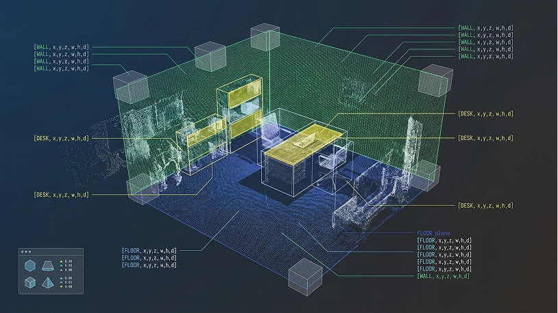
3D Point Cloud Annotation Services

Unidata offers advanced 3D point cloud annotation services, focusing on precise labeling and tagging to enhance object detection, scene understanding, and spatial analysis across diverse industries and applications. Our meticulous approach ensures high-quality annotations that drive the performance of your AI models.
- 95%+ annotation accuracy
- 1,000+ domain-matched annotators
- Pilot launched within days
Annotation Vs Labeling Tasks
| 3D Point Cloud Data Annotation | 3D Point Cloud Data Labeling | |
|---|---|---|
| Definition | Precise marking of individual points, objects, and surfaces within 3D point cloud data, including geometric boundaries, semantic classification per point, and spatial relationships | Assigning classification labels to entire point cloud clusters, scenes, or simple object presence without detailed point-level precision |
| Annotation Depth | Comprehensive: processes every point in the cloud, captures fine geometric details, identifies occlusions, maps object relationships, and maintains temporal consistency across sequential frames | Selective: processes at cluster or scene level, captures only object categories or scene types without point-level detail, and treats frames independently without temporal linkage |
| Common Tasks | • Point-wise semantic segmentation • 3D bounding cuboids around objects • Instance segmentation in point clouds • Surface normal estimation marking • Object pose and orientation annotation • Occlusion boundary identification • Scene completion annotation • Multi-object tracking across sweeps • Free space vs. occupied space marking • Ground plane segmentation | • Object-level classification (car/truck/pedestrian/cyclist) • Scene type classification (intersection/highway/parking lot) • Simple object presence/absence detection • Cluster-level categorization • Weather/lighting condition tagging • Basic obstacle vs. non-obstacle labeling • Zone-based occupancy counting |
| Complexity Level | Extremely high complexity: requires deep understanding of 3D geometry, sensor characteristics, point cloud density variations, occlusion patterns, and temporal consistency across frames | Medium complexity: requires basic point cloud interpretation skills and ability to identify objects in 3D space without fine-grained segmentation |
| ML Impact | Enables: autonomous driving perception systems, robotics navigation, environment reconstruction, precise obstacle detection and tracking, sensor fusion models, 3D scene understanding | Enables: coarse object detection, scene classification, basic environment monitoring, traffic flow analysis, occupancy estimation |
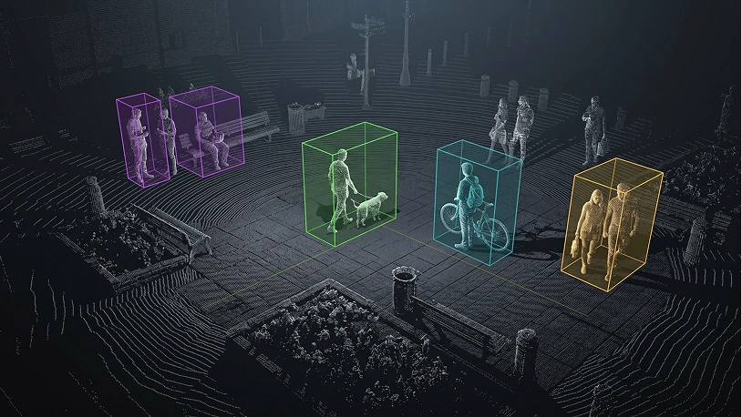
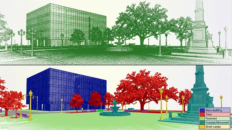
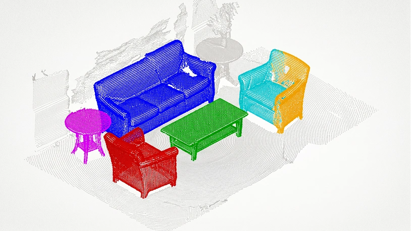
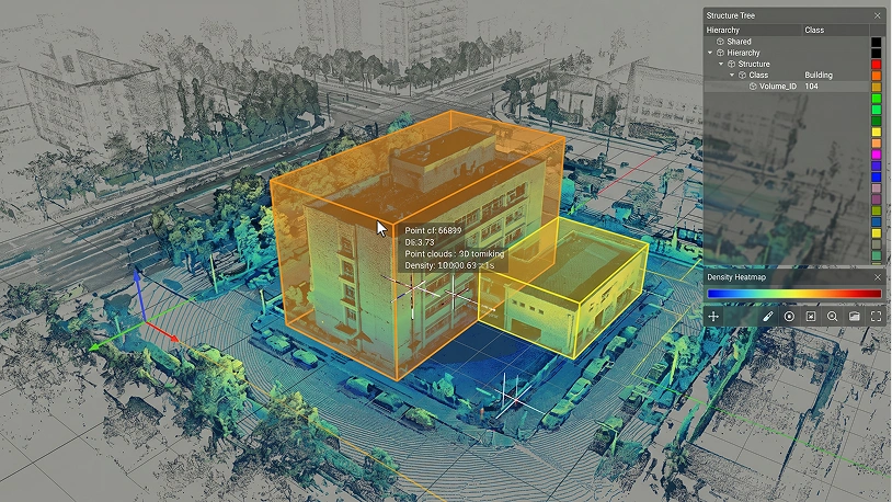
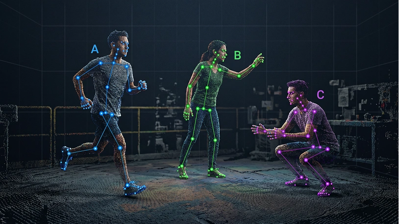
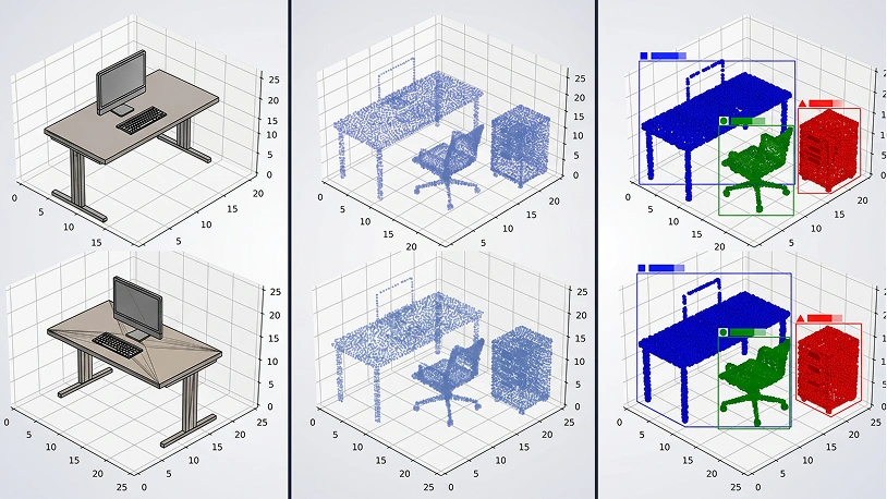
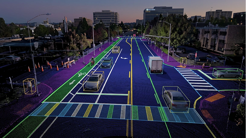
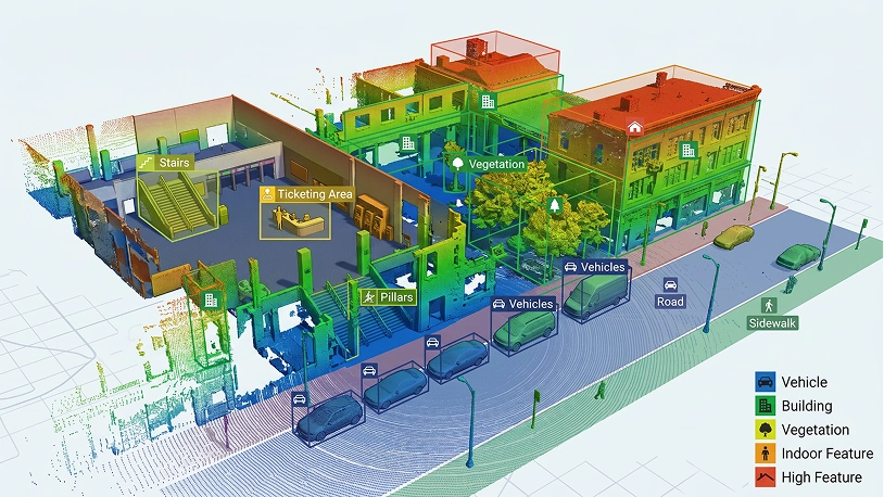
3D Point Cloud Annotation Types
Software We Use
SuperAnnotate
SuperAnnotate is a robust annotation platform that offers advanced tools for both 2D and 3D data annotation. It excels in handling complex 3D point cloud datasets with high precision and efficiency, making it ideal for projects that require detailed annotation.
Best For:
Teams needing a powerful, AI-assisted platform for managing and annotating complex 3D point cloud data in large-scale projects.
Key Features
- Supports 3D point cloud annotation, including 3D bounding boxes and segmentation.
- AI-assisted tools for accelerating annotation workflows.
- Collaboration tools for managing large teams and complex projects.
- Integration with popular machine learning frameworks and cloud storage solutions.
Labelbox
Labelbox is a versatile annotation platform that extends its capabilities to 3D data, including point clouds. It offers comprehensive tools for managing and annotating 3D data, combined with strong project management and collaboration features.
Best For:
Enterprises and teams seeking a scalable solution for managing and annotating 3D point cloud data with robust project management capabilities.
Key Features
- AI-powered tools for 3D point cloud segmentation and object classification.
- Supports various 3D annotation types, including 3D bounding boxes and instance segmentation.
- Integrated project management features for tracking progress and team collaboration.
- API support for seamless integration with machine learning pipelines.
CVAT (Computer Vision Annotation Tool)
CVAT is an open-source annotation tool developed by Intel that supports a wide variety of annotation tasks, including 3D point cloud annotation. It is known for its flexibility and customizability, making it ideal for detailed and specialized 3D annotation projects.
Best For:
Developers and researchers who need a customizable, open-source tool for detailed 3D point cloud annotation tasks.
Key Features
- Supports 3D point cloud annotation, including 3D bounding boxes and segmentation.
- Customizable interface with scripting capabilities for specialized tasks.
- Free and open-source, with active community support.
- Suitable for handling large datasets with complex annotation requirements.
CloudCompare
CloudCompare is an open-source 3D point cloud processing software that includes robust annotation capabilities. It is particularly well-suited for handling large point cloud datasets and offers a range of tools for both basic and advanced annotation tasks.
Best For:
Teams and individuals needing a powerful, open-source tool for comprehensive 3D point cloud processing and annotation.
Key Features
- Supports 3D point cloud annotation, including segmentation and point labeling.
- Advanced point cloud processing tools for cleaning, filtering, and analyzing data.
- Free and open-source, with extensive documentation and plugin support.
- Handles large datasets efficiently, making it ideal for projects requiring detailed 3D analysis.
3D Slicer
3D Slicer is an open-source software platform primarily used for medical imaging, but it also supports robust 3D point cloud annotation capabilities. It is particularly strong in handling volumetric data and is widely used in medical and research applications.
Best For:
Medical researchers and professionals requiring advanced tools for annotating and analyzing 3D point cloud data, particularly in healthcare applications.
Key Features
- Supports 3D point cloud annotation, including volumetric segmentation and landmark labeling.
- Extensive tools for medical imaging data, including CT, MRI, and ultrasound.
- Open-source with a large user community and comprehensive documentation.
- Customizable with a wide range of plugins and extensions.
VoTT (Visual Object Tagging Tool)
VoTT by Microsoft is an open-source annotation tool that supports both 2D and 3D data. While primarily known for 2D annotations, it also provides capabilities for annotating 3D point clouds, making it a versatile option for teams working with mixed data types.
Best For:
Teams needing a flexible tool that can handle both 2D and 3D annotation tasks, particularly those integrating with Microsoft Azure services.
Key Features
- Supports 3D point cloud annotation, including 3D bounding boxes and object classification.
- Integration with Azure ML and other cloud services for seamless data processing.
- User-friendly interface that simplifies the annotation process.
- Free and open-source, with active community support.
Scalabel
Scalabel is an open-source, scalable platform designed for collaborative annotation of both 2D and 3D data. It supports a variety of 3D annotation types, making it suitable for projects that involve large datasets and require precise annotation tools.
Best For:
Teams and organizations needing a scalable and collaborative platform for large-scale 3D point cloud annotation projects.
Key Features
- Supports 3D point cloud annotation, including 3D bounding boxes, segmentation, and object tracking.
- Real-time collaboration tools for team-based projects.
- Scalable architecture for handling large datasets efficiently.
- Open-source, allowing for customization and integration with existing workflows.
How Unidata Provide Data Labelling Process
A Clear, Controlled Workflow From Brief to Delivery
- You
- Share your raw data, annotation requirements, and quality standards
- Unidata
- We analyze your data, define the methodology, and assign a dedicated project lead. The right annotation type and domain-matched annotators are confirmed before anything starts.
- You
- Review annotated samples, validate quality, and approve scope before full-scale work begins.
- Unidata
- We annotate a small representative sample and deliver a clear cost estimate broken down by complexity, hours, and validation rounds.
- You
- Review and sign. Scope, quality thresholds, and deadlines are all defined in writing upfront.
- Unidata
- We prepare a full confidentiality agreement covering your data, guidelines, and any proprietary model details.
- You
- Share existing guidelines and format requirements. No guidelines yet? We build them together.
- Unidata
- We configure the right annotation platform for your data type: Labelbox, SuperAnnotate, CVAT, or Label Studio. Workflows, label taxonomy, and quality benchmarks are set before a single label is applied.
- You
- Review sample batches at each milestone and share feedback with your project lead.
- Unidata
- Trained, domain-matched annotators work through your dataset. No batch moves forward without passing internal quality checks.
- You
- Review edge cases and confirm acceptance criteria before final delivery.
- Unidata
- Every batch goes through automated validation and human review. Inter-annotator agreement (IAA) is tracked throughout. Inconsistencies are caught and resolved before the dataset moves forward.
- You
- Receive your annotated dataset in the format you need: COCO, Pascal VOC, JSON, CoNLL, PCD, or custom. Full quality report included.
- Unidata
- Clean, validated, training-ready data delivered on schedule. Final invoice aligned to the scope agreed at Step 02.
Have questions about the process? Every project starts with a free consultation — no commitment required.
Data Annotation Challenges? Value You Get with Unidata
Real Challenges
- No annotators, tools, or workflow to process collected data
- No quality check on labeled data before it hits the pipeline
- No way to ensure two annotators label the same object consistently
- Can’t find annotators with LiDAR, medical, or financial expertise
- Scope creep and rework cycles exhaust the budget before delivery
Value with Unidata
- Project lead assigned and pilot launched within days
- Every batch validated before delivery, 95%+ accuracy via multi-stage QA
- Label consistency tracked per batch, issues caught before training fails
- 1,000+ annotators matched by domain — the right expert, every time
- Pilot-first pricing, fixed scope, zero hidden rework charges
Files Example
Working with annotation data from CVAT and JSON formats, you'll receive optimized code that seamlessly processes both file types, complete with practical examples and visual representations of your data structure.
Other Services
Ready-Made Datasets
Get our ready-made datasets to enhance the quality of your models and improve testing

Data Collection
Collect and enhance diverse image, video, text, and audio data for your business

Data Annotation
Get accurate data labeling and annotation for your machine learning projects

LLM Training Services
Comprehensive data services for training, evaluation, and testing of LLM models across 12 industries

What our clients are saying
UniData

Data purchase
Our team got in touch with UniData for purchasing video data. The team at UniData was transparent, timely, and pleasant to communicate and negotiate with. Their samples and descriptions aligned well with the data we received. We will certainly reach out to UniData again if we're in search of 3rd party video data.
FAQ
Industries
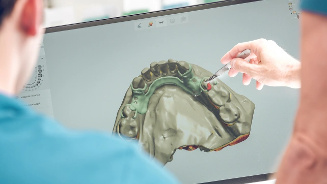
Healthcare
Anatomical 3D reconstruction from scans for surgical planning and precise treatment decisions.

Automotive
LiDAR-based environment mapping for real-time navigation and collision avoidance systems.

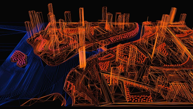
Construction & Architecture
Accurate building models and site scanning for better planning and resource management.

Real Estate
Virtual property tours and spatial visualization for immersive remote viewing experiences.

Security & Surveillance
3D environment modeling for enhanced threat detection and real-time monitoring systems.

Manufacturing
Quality control, defect detection, and predictive maintenance through product scanning.

Aerospace
Aircraft component mapping for design improvement, safety monitoring, and maintenance.
Energy & Utilities
Infrastructure modeling for power plants, pipelines, and predictive maintenance systems.
Why Companies Trust Unidata’s Services for ML/AI
Share your project requirements, we handle the rest. Every service is tailored, executed, and compliance-ready, so you can focus on strategy and growth, not operations.
Ready to get started?
Tell us what you need — we’ll reply within 24h with a free estimate

- Andrew
- Head of Client Success
— I'll guide you through every step, from your first
message to full project delivery
Thank you for your
message
We use cookies to enhance your experience, personalize content, ads, and analyze traffic. By clicking 'Accept All', you agree to our Cookie Policy.