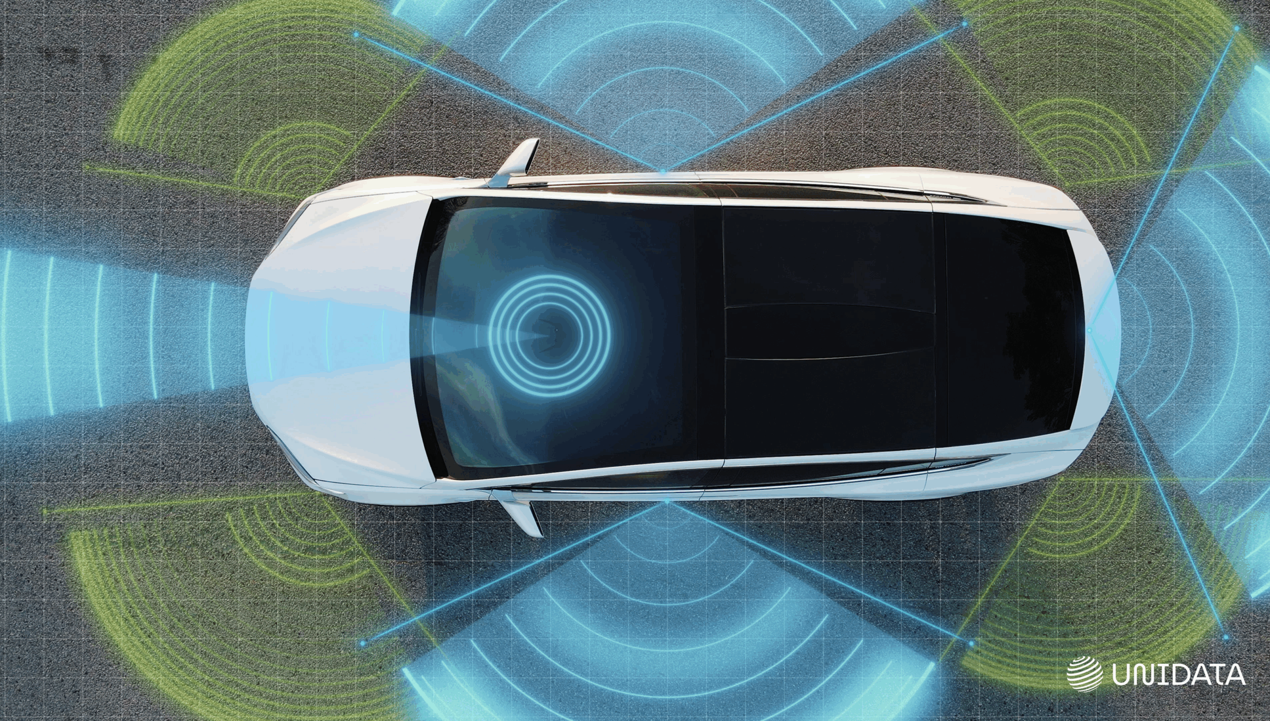
They both “see” the world — but in totally different ways. Lidar sketches every curve and corner in laser-sharp detail. Radar? It powers through fog, rain, and chaos like nothing else.
Mix them up, and your drone might miss a tree — or your car might miss a crash.
This article breaks down:
- How Lidar and Radar really work
- Which one fits your use case
- And why the smartest systems use both
Let’s dive in.
What Is Lidar?
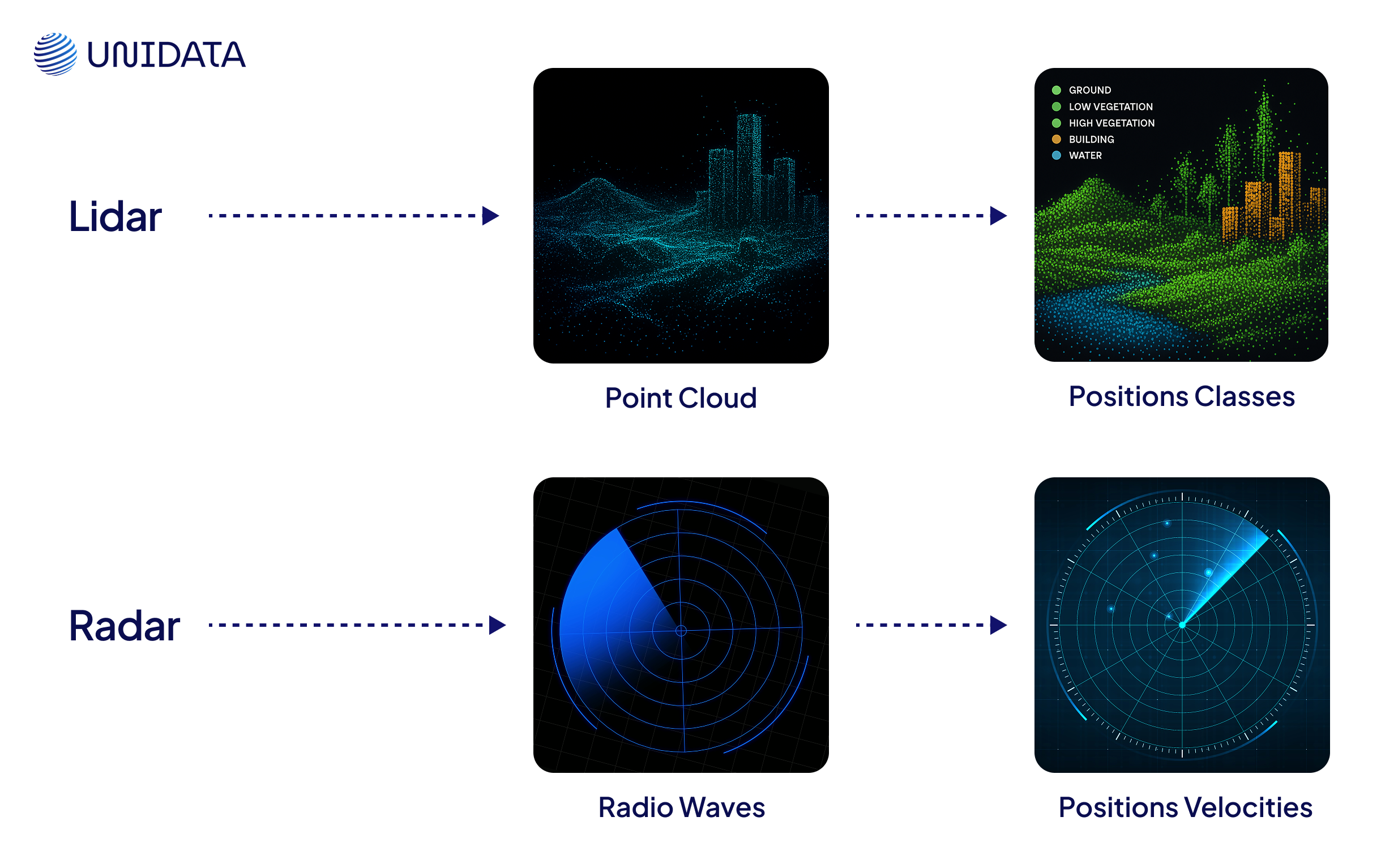
Lidar stands for Light Detection and Ranging — a mouthful, but the idea is simple. It fires out thousands of tiny laser pulses every second, then measures how long they take to bounce back. From that, it builds an ultra-precise 3D map of the world around it.
No guesswork. Just light-speed math.
Unlike cameras, Lidar doesn’t care about colors or textures. It sees shape, depth, and distance — down to a few centimeters.
That’s why it’s become the go-to for autonomous cars, drones, and robots navigating tight, obstacle-filled spaces.
What Makes It Special:
- Shoots laser pulses to calculate the exact distance to objects
- Builds dense 3D point clouds — perfect for mapping roads, terrain, or warehouse shelves
- Excels in static, controlled environments (think sunny streets or indoor robots)
- But it's vulnerable to fog, dust, and rain — light doesn’t like interference
Think of it like scanning a room with a laser pointer hooked up to a tape measure. Each pulse adds another dot to a 3D model — until you’ve mapped the entire space in stunning detail.
What Is Radar?
Radar stands for Radio Detection and Ranging.
Instead of light, it uses radio waves — those long, low-frequency waves that can pass through fog, dust, and even walls in some cases.
It’s been used for decades in aviation, maritime safety, and weather prediction. But now, it's being reimagined for self-driving cars, industrial robotics, and smart cities.
Radar isn’t about beauty — it’s about reliability.
Where Lidar might panic in a snowstorm, Radar keeps a steady hand. It can spot fast-moving objects, gauge their speed using the Doppler effect, and do it all without needing perfect conditions.
What Makes It Powerful:
- Sends out radio waves that reflect off objects — even in poor visibility
- Measures not just distance, but velocity and direction
- Performs consistently in challenging environments — night, rain, fog, you name it
- Offers longer range and uses less power than Lidar
Radar doesn’t capture every contour — but it keeps your system aware of everything that matters.
If Lidar gives you a crisp architectural rendering, Radar gives you a heat map of motion and threats.
And in rough conditions? That’s often all you need.
Key Differences at a Glance
Now that we’ve covered what each one is and how it works in broad strokes, let’s break down where Lidar and Radar truly diverge — because understanding the mechanics is one thing, but the real decisions come down to how they perform side by side.
Signal type:
Lidar uses laser light; Radar uses radio waves. That alone sets the stage for everything else — resolution, reliability, and what kind of environments they can handle.
How They Work (Step-by-Step Breakdown)
Specs are helpful — but real insight comes from knowing what’s happening moment by moment. Here’s how each system actually senses the world around it, from the first signal to the final decision.
How Lidar Works:
It all starts with light. The Lidar unit sends out thousands of laser pulses per second, sweeping across its surroundings like an invisible scanner.
- Emission – The sensor blasts rapid-fire laser beams in all directions.
- Reflection – Those beams hit nearby objects — walls, trees, people — and bounce back.
- Timing – The system clocks how long each pulse took to return.
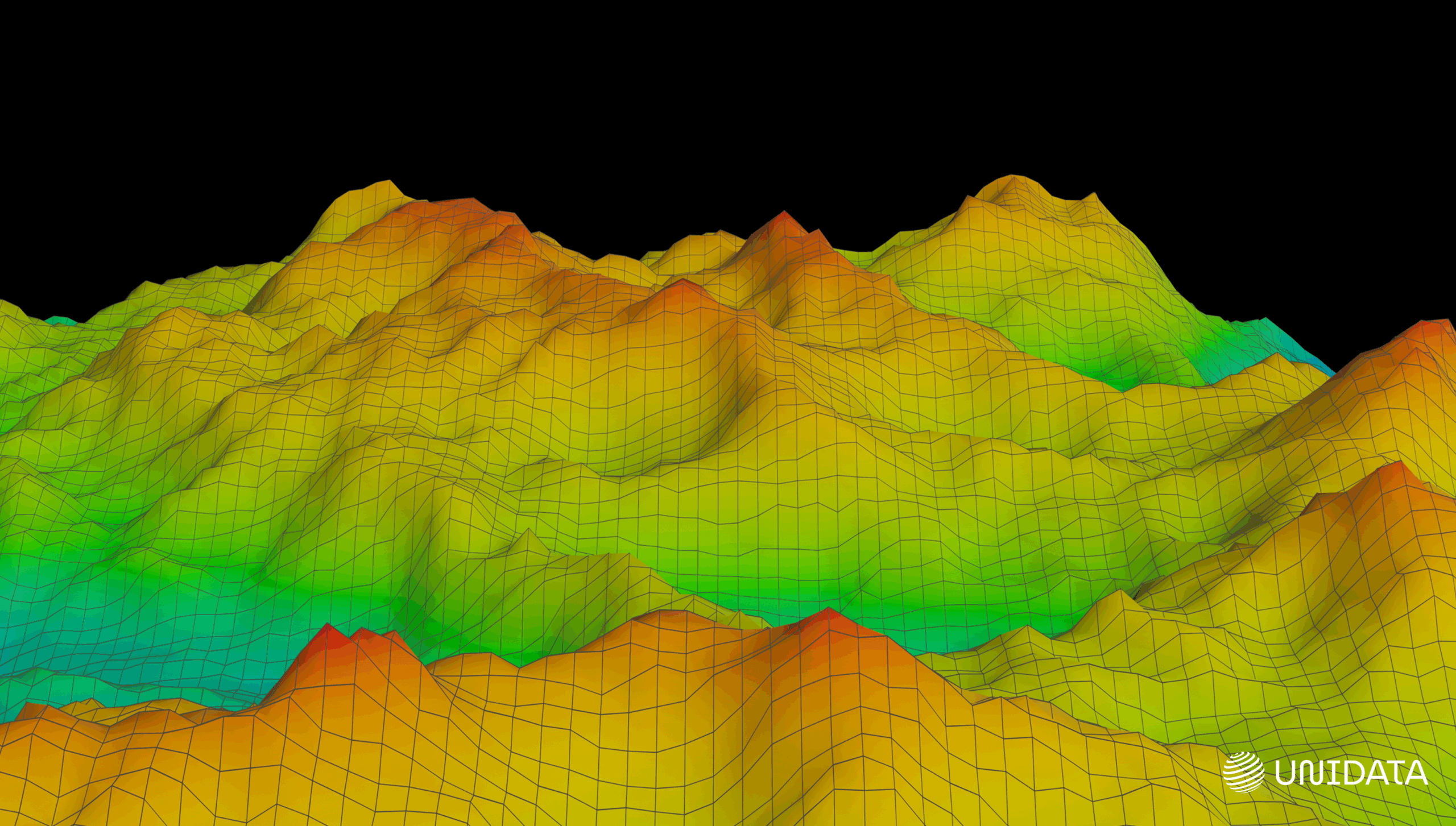
- Mapping – It crunches the timing data to calculate distances, building a detailed 3D point cloud of the scene.
- $$c$$ is the speed of light
- $$t$$ is the time of flight (there and back)
This point cloud becomes the machine’s view of the world: dense, precise, and depth-rich.
How Radar Works:
Radar skips the fine detail and goes straight for the essentials. It uses radio waves, not light, which means it can cut through fog, dust, and even some walls.
- Transmission – The radar module emits bursts of radio waves into its surroundings.
- Reflection – These waves bounce off objects and return as echoes.
- Processing – The system measures the time delay and — crucially — the frequency shift of each return.
- Interpretation – From this, it calculates the distance, speed, and direction of every detected object.
To compute distance, Radar uses the same principle as Lidar:
$$$ \text{Distance} = \frac{c \times t}{2} $$$Where:
- $$c$$ is the speed of radio waves (≈ speed of light)
- $$t$$ is the round-trip time delay
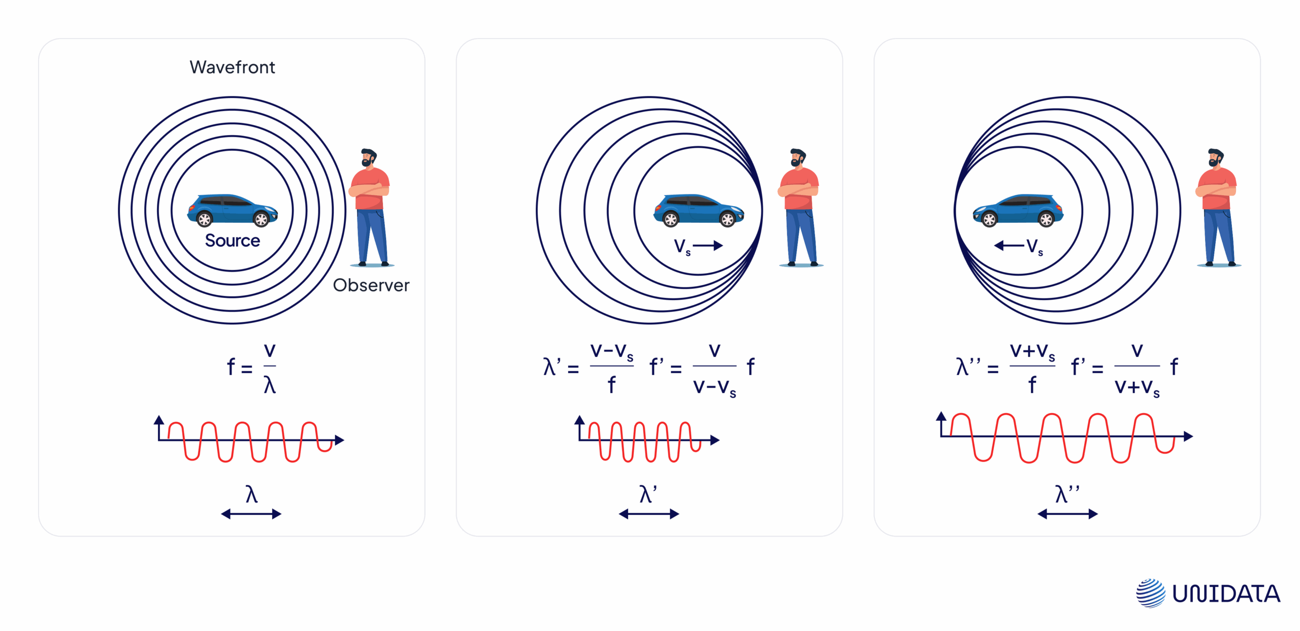
But here’s where Radar gets ahead: it uses the Doppler effect to detect motion. When an object moves toward or away from the radar, the frequency of the reflected wave changes. That shift tells us the object’s speed.
$$$ v = \frac{f_d \times c}{2 \times f_0} $$$Where:
- $$v$$ is the relative velocity
- $$fd$$ is the Doppler shift (change in frequency)
- $$f_0$$ is the original transmitted frequency
- $$c$$ is the speed of light
Lidar shows you where everything is. Radar tells you what’s moving, how fast, and in which direction. And depending on your use case, that difference can make or break your system.
Accuracy, Range, and Resolution
Once you know how each system works, it’s time to ask the big questions: How precise are they? How far can they see? And what kind of picture do they give you?
Let’s unpack that.
Accuracy
Lidar is the king of precision. It delivers sub-centimeter accuracy in 3D spatial mapping — often down to a few millimeters. That’s why it’s used for jobs like curb detection, obstacle avoidance in indoor robotics, and creating HD maps for autonomous vehicles.
$$$ \text{Typical Accuracy} \approx \pm 2\,\text{cm} $$$Radar, in contrast, isn’t built for fine shape detection. But it excels in tracking motion, thanks to the Doppler shift. It can measure the speed of an object with impressive reliability — especially useful when something’s moving toward you fast.
$$$ v = \frac{f_d \times c}{2 \times f_0} $$$So while Lidar tells you what and where, Radar adds how fast.
Range
When it comes to distance, Radar clearly wins. Long-range automotive radar can detect vehicles, bikes, or pedestrians up to 250+ meters away, and do it in bad weather, at night, or through fog.
Lidar’s range depends on the hardware. Most systems work best within 50 to 150 meters, with accuracy degrading in rain or heavy mist.
- Lidar max range (high-end models): ~200 m (ideal conditions)
- Radar max range: ~250–300 m (all conditions)
If you’re building for freeway-speed scenarios or long-distance tracking, Radar’s your tool. Lidar shines more in urban and indoor settings, where fine detail matters more than raw distance.
Resolution
This one’s easy: Lidar crushes it.
Lidar sensors fire hundreds of thousands to millions of pulses per second, generating rich 3D point clouds. These point clouds let machines “see” buildings, tree lines, road textures — even the edges of a loading dock or a pothole.
Radar paints a broader picture. It provides fewer data points, which means you won’t get crisp object outlines. Instead, you’ll detect presence, shape, and speed — but the visuals are closer to blobs than blueprints.
This is why many systems pair both:
Lidar gives you geometry. Radar gives you movement. Put them together, and your machine sees with both clarity and context.
Cost, Setup, and Real-World Limitations
No sensor is perfect — and no budget is unlimited. So once you’ve looked at performance, it’s time to get practical:
How much does it cost? How hard is it to deploy? And where might it let you down?
Let’s get into the tradeoffs.
Lidar: High-Detail, High-Maintenance
Lidar units used to cost thousands of dollars each — especially the spinning mechanical types common in early self-driving cars. Solid-state models like Velodyne’s Velarray or Luminar’s Iris are now bringing that down to the $500–1000 range, but that’s still a serious investment for multi-sensor systems.
Setup isn’t always plug-and-play, either. Lidar units:
- Require precise mounting to avoid vibration artifacts
- Need clean line-of-sight to the environment
- Often demand heavy onboard processing to convert point clouds into usable maps
And in messy real-world conditions?
- Fog, rain, or dust can scatter laser beams and create noise
- Reflective surfaces like glass or water can cause false returns
- Even bright sunlight can reduce accuracy in cheaper models
Radar: Cheaper, Stronger, But Not Prettier
Radar wins on cost. Many modules — especially for automotive use — come in under $100 per unit, with mature supply chains and long lifecycle guarantees. That’s why it’s favored in large-scale deployments like fleets or infrastructure.
It’s also much easier to integrate:
- Works well at low resolution
- Requires less compute power
- Handles bad weather without flinching
But it’s not without limitations:
- Low spatial resolution: Radar can’t tell a cyclist from a pole at 3 meters
- RF interference: In crowded environments (e.g., ports or cities), Radar signals can clash
- Vertical blind spots: Without stacking multiple antennas, low-angle targets may go unnoticed
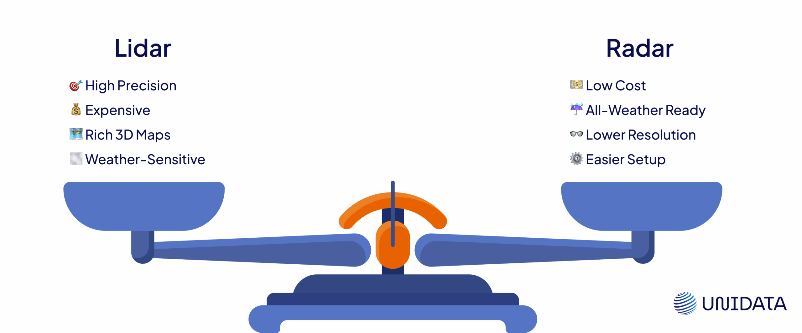
Lidar brings precision but demands more budget, power, and planning. Radar is cheaper and sturdier, but you trade off detail for dependability.
Real-World Use Cases
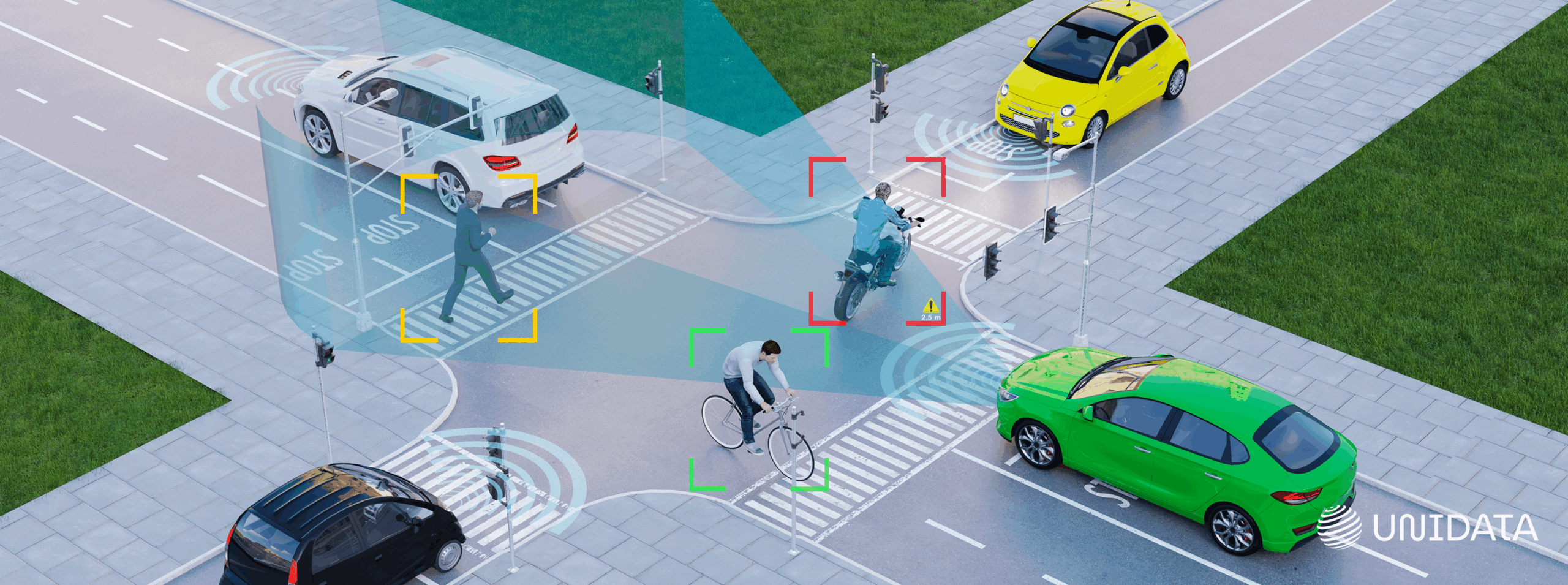
You’ve seen the specs — now let’s look at where these sensors actually go to work. Spoiler: most real-world systems don’t choose one or the other. They combine both.
Autonomous Vehicles
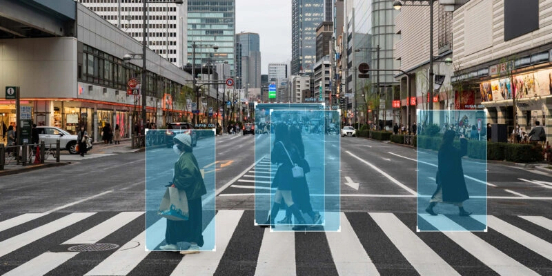
Self-driving cars rely on layered perception, and Lidar plus Radar is a common combo. Radar handles fast-moving vehicles in fog or rain, where vision and Lidar often struggle. Lidar takes care of lane positioning, curb detection, and spotting cyclists or pedestrians with millimeter-level detail. Tesla famously dropped Lidar to bet on vision and Radar alone, while Waymo doubled down on multi-Lidar arrays for full 360° spatial awareness.
Drones and Aviation
Lidar is ideal for drones flying low and mapping terrain in high detail — think agriculture, construction, or archaeology. It captures slopes, gaps, and textures that GPS and cameras miss. Radar, meanwhile, plays a critical role in aviation altimeters and collision-avoidance systems, where long-range detection and weather resistance are non-negotiable.
Robotics and Warehousing

Robots need fine-grain vision to safely navigate crowded indoor spaces. Lidar helps them detect boxes, shelves, and people with centimeter-level accuracy. Radar complements that by tracking speed and direction — especially for fast-moving equipment like forklifts or for detecting people behind corners.
Smart Cities and Infrastructure
Cities are already embedding Radar sensors at intersections to monitor traffic flow and detect speeding, even in heavy rain. Lidar comes in for the fine work: scanning potholes, capturing curb geometry, or building 3D maps that support everything from sidewalk repairs to automated snow removal.
Final Takeaways
Lidar gives you precision — ideal for mapping, navigation, and anything that needs fine-grain spatial detail. Radar delivers reliability — built for long-range detection and all-weather performance.
If you’re choosing just one, it depends on what matters more: clarity or resilience. But in most real-world systems, the smartest move isn’t picking sides. It’s combining both.
Frequently Asked Questions (FAQ)
The key difference in LiDAR vs Radar is the type of signal used. LiDAR relies on laser light to generate high-resolution 3D maps with precise spatial detail, while radar uses radio waves to detect objects, measure distance, and track motion. LiDAR excels in accuracy and mapping, whereas radar is stronger in range and reliability.
In the LiDAR vs Radar comparison, LiDAR uses laser pulses to capture fine details and create dense 3D point clouds, making it ideal for mapping and object recognition. Radar uses radio waves that travel farther and penetrate fog, rain, and dust, making it better for detecting objects and tracking their speed in harsh environments.
No, in the LiDAR vs Radar debate, LiDAR cannot fully replace radar. While LiDAR provides superior detail and spatial accuracy, radar offers better performance in poor weather and can measure object velocity using the Doppler effect. Most real-world systems combine both technologies for safer and more reliable perception.
When comparing LiDAR vs Radar for autonomous systems, neither is universally better. LiDAR is ideal for precise navigation and obstacle detection, while radar ensures consistent performance in low visibility and long-range scenarios. The most effective systems use sensor fusion, combining LiDAR, radar, and cameras.
Choosing between LiDAR vs Radar depends on your application. LiDAR is best for high-detail tasks like 3D mapping, robotics, and indoor navigation. Radar is better suited for long-range detection, motion tracking, and operation in challenging weather conditions, such as in automotive safety and aviation systems.